Iklan
Pertanyaan
Choose the correct answer!
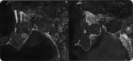
Two IKONOS satellite images showing the coastal community of Banda Aceh, Indonesia, before (left) and after (right) the tsunami. Towns were completely destroyed and most trees, vegetation, shrimp farms, and buildings were washed away when the tsunami hit with a height at the shore of more than 50 feet (15 m). Agricultural lands behind were covered with salt water for days after the tsunami, and sand from the beachfront was completely removed. (CORBIS)
Source: Tsunamis
What is the left image about?
What is the left image about?
Tsunami in Aceh.
The coastal community of Aceh before the tsunami.
The condition of Aceh before and after tsunami.
The agricultural lands in Indonesia.
The beachfront of beaches in Aceh.


Iklan
H. Nz
Master Teacher
Mahasiswa/Alumni Universitas Padjadjaran
Jawaban
jawaban yang benar adalah B. The coastal community of Aceh before the tsunami.
Pembahasan
Untuk menjawab pertanyaan di atas, kita harus membaca caption foto tersebut. Pada kalimat pertama dalam caption , " Two IKONOS satellite images showing the coastal community of Banda Aceh, Indonesia, before (left) and after (right) the tsunami, " kita mendapatkan informasi bahwa foto yang sebelah kiri adalah foto komunitas pantai di Aceh sebelum tsunami. Jadi, jawaban yang benar adalah B. The coastal community of Aceh before the tsunami.
Untuk menjawab pertanyaan di atas, kita harus membaca caption foto tersebut. Pada kalimat pertama dalam caption, "Two IKONOS satellite images showing the coastal community of Banda Aceh, Indonesia, before (left) and after (right) the tsunami," kita mendapatkan informasi bahwa foto yang sebelah kiri adalah foto komunitas pantai di Aceh sebelum tsunami.
Jadi, jawaban yang benar adalah B. The coastal community of Aceh before the tsunami.


Perdalam pemahamanmu bersama Master Teacher
di sesi Live Teaching, GRATIS!
2
0.0 (0 rating)
Iklan

Pertanyaan serupa
RUANGGURU HQ
Jl. Dr. Saharjo No.161, Manggarai Selatan, Tebet, Kota Jakarta Selatan, Daerah Khusus Ibukota Jakarta 12860
Coba GRATIS Aplikasi Roboguru

Coba GRATIS Aplikasi Ruangguru


Produk Ruangguru
Bantuan & Panduan
Hubungi Kami

Ikuti Kami


©2026 Ruangguru. All Rights Reserved PT. Ruang Raya Indonesia